
TOPICS FOR CLASS III
MODELS:
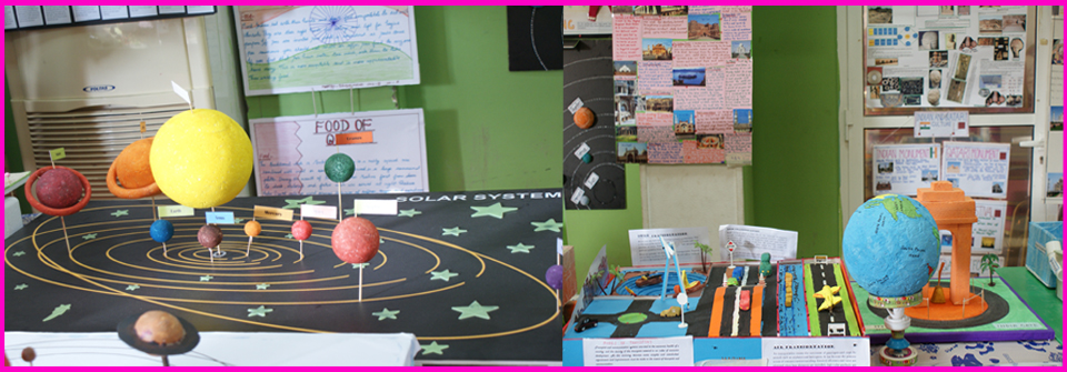
1. The Solar System.
2. The Rotation and Revolution of the earth.
3. Landforms or natural features such as mountains, hills valleys,
plateaus, plains, peak, mountain range, river, coast and ocean.
4. The invention of the wheel.
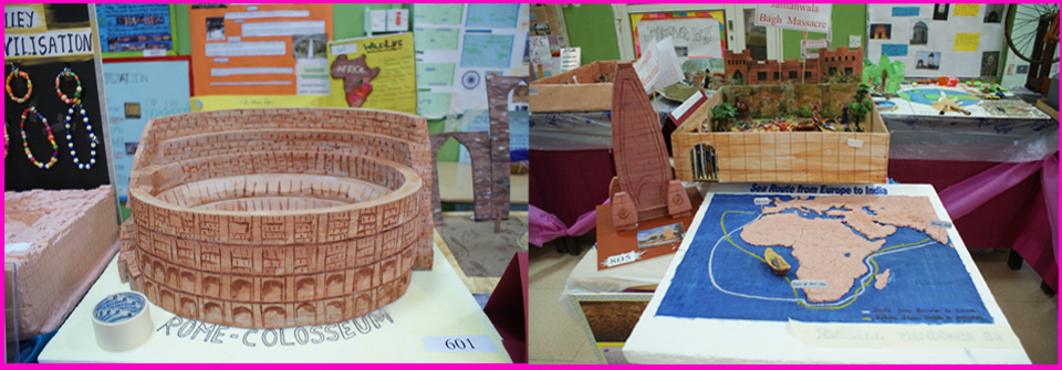
5. Civilizations – (a)Egypt, (b)Harappa.
6. Neighbourhood Services – Bank, Post office, School, Shopping
Malls, Bus-stop, Hospital, etc.
7. The different uses of the wheel.
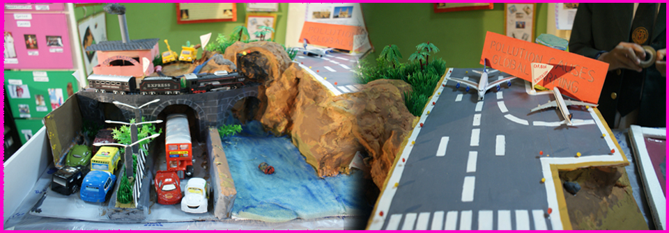
8. The different means of transport.
9. The famous buildings and monuments of Delhi, Kolkata, Chennai
and Mumbai.
10. The difference between a peninsula and an island.
CHARTS:
1. Clothes worn by the men and women of India and during different
seasons.
2. The Egyptian style of writing, hieroglyphics – New sentences
can be framed using hieroglyphics.
3. The different festivals celebrated by the people of India.
4. The different dance forms of the people of India.
5. Safety at home, school and on the road – Slogans, Road Signs.
6. Landforms or natural features such as mountains, hills,
valleys, plateaus, plains, peak, mountain range, river, coast and
ocean.
QATAR HISTORY:
CHARTS:
1. Important land marks of Qatar.
2. National Symbols of Qatar.
3. Archaeological landmarks of Qatar.
TOPICS FOR CLASS IV
MODELS:
1. The Globe.
2. The different landforms and regions of India – The Northern
Mountain Range, the Northern plains, the Desert Region.
3. A forest reserve or wildlife sanctuary of India.
4. A dam/ production of hydroelectricity.
5. Oil Refinery.
6. Monuments found in India.
7. The different means of communication.
8. The different types of foodcrops of India (Samples).
CHARTS:
1. The difference between afforestation and
deforestation.
2. The different types of foodcrops of India (Samples in chart).
3. The different means of communication.
4. The different landforms and regions of India – The Northern
Mountain Range, the Northern plains, the Desert Region.
5. A forest reserve or wildlife sanctuary of India.
6. Clothes worn during different seasons in India.
QATAR HISTORY
CHARTS:
1. Important land marks of Qatar.
2. National Symbols of Qatar.
3. Archaeological landmarks of Qatar.
TOPICS FOR CLASS V
MODELS:
1. Natural Disasters
2. Pollution
- Air
- Water
- Noise
- Soil
3. Movement of the Earth and their Effects (Rotation and
Revolution)
4. Heritage ( Monuments from India)
5. Our Earth
6. UN Symbol
CHARTS
1. Pollution
- Air
- Noise
- Water
- Soil
2. Freedom Struggle
- Freedom fighters
(Jhansi Rani, Gandhiji, Netaji, Sarojini Naidu, Bagath
Singh, Anne Besant)
- Jallianwala Bagh, Salt March etc.
- Old pictures, articles related freedom struggles
3. UN – List of the Secretaries, types of flags with different
countries
QATAR HISTORY (Chart or model)
1. Landmark
2. Social Values
- Culture
- Food
- Costumes
- Festivals.
TOPICS FOR CLASS VI
HISTORY - MODELS/CHARTS
1. Early settlements
- Earliest living, farmers and herders
2. Harrappan civilization
- Great Bath, Teracota, clay jewellery, seals etc.
3. Ancient Empires
- Mauryas, Guptas
4. Ancient monuments
- Sanchi Stupa, iron pillar etc.
5. Unity in Diversity
- Dress, food, festivals etc.
6. Livelihoods
- Rural Vs Urban comparison
GEOGRAPHY - MODELS/CHARTS
1. All the four spheres- Lithosphere,
Hydrosphere, Atmosphere and Biosphere
2. Lithosphere can be included with different landforms, seabed,
continents, islands, mountains etc.(Models)
3. Hydrosphere refers to water cycle (Chart)
4. Atmosphere refers to different composition of gases and layers
of gases (chart)
5. Biosphere refers to summation of the three spheres leading to
life, eco system-food cycle-forest-flora and fauna, disturbances,
preventive measure(models/chart)
TOPICS FOR CLASS VII
HISTORY -
MODELS/CHARTS
1. Medieval Architecture
a) Delhi Sultanate
b) Mughal empire
2. Tribal communities
CHARTS
1. Social Advertising
1) Protecting wild life
2) Slogans based on Senior Citizens
3) Slogans on Vaccination and Immunization campaign
4) save water/ electricity
5) slogans helping girl child
GEOGRAPHY -
MODELS/CHARTS
1. The earth’s interior structure core/mantle
and crust of the earth.(modules)
2. Layers or composition of atmosphere.(model for pie chart/ chart
work for graphical presentation)
3. Rock cycle-chart
4. Volcano – model, Earthquake- chart
5. Models/Charts showing the fluvial erosional landforms.(eg, v
shaped valley, gorge, waterfall)
6. Models/Charts showing the fluvial depositional
landforms.(alluvial plains, meander, ox bow lake, natural levees,
delta)
TOPICS FOR CLASS VIII
HISTORY -
MODELS/CHARTS
1. The establishment of British Government in
India (Cut out’s and Charts of the British officers)
2. Revolt of 1857 (Model of Enflied Riffle)
3. Art and Literature- Collect pictures of different schools of
art in the colonial period.
4. Indian National movement (Glimpses from the Indian freedom
struggle. – Model of Jallianwala Bagh Massacre, Quit India, Simon
Commission, Dandi March)
5. India and her neighbours (Chart)
6. Parliament House, Supreme Court, High Court - (Models)
GEOGRAPHY –
MODELS
1 Working Model on any one:
a.Iron &Steel Industries
b.Oil Refinery
c. Software Technology Park
CHARTS
2. Preparation of chart on the following:
a.Green Revolution
b. Different Crops Grown in different parts of India
c. Demography (Population Pyramid,Literacy Rate, Sex Ratio,
Density, Distribution etc.
TOPICS FOR CLASS IX
HISTORY – MODELS
1. THE FRENCH REVOLUTION: bastille prison, political symbols of
the revolution, versailles palace
2. NAZISM & HITLER: rallies, trenches, weapons, aircrafts, tanks,
submarines used in the two world wars, Volkswagen
3. CLOTHING : khadi & charka
CHARTS
1. FRENCH ARISTOCRACY
2. NAZISM & HITLER: red banners with swastika
3. CLOTHING: changes in dress styles : Europe & USA
4. Nelson Mandela – His life history
GEOGRAPHY – MODELS/CHARTS
1. Tourism in mountains.
2. Mountain sports.
3. Natural disasters in mountainous areas.
4. Formation of springs, geysers and waterfalls.
5. Plate Tectonics movements.
6. Formation of Gorges & canyons.
7. Maps showing mountain ranges of the world.
TOPICS FOR CLASS X
HISTORY –
MODELS/CHARTS
1. Nationlism
- India – related to Indian nationalist movements
- Unification of Italy, Germany etc.
GEOGRAPHY - MODELS/CHARTS
1. Models/Charts of various landforms formed by coastal erosion
along with their features
2. Models/ charts of different landforms formed by coastal
deposition along with their features
3. Any other creative treatment of the topic may be accepted after
conferring with your respective teacher
ECONOMICS – MODELS/CHARTS
Globalisation